Saturday, March 2, 2013
Four weeks of climate data:
Northern Temperate Region #6
Our last region of Asia is mainly the Kamchatka Peninsula and a whole lot of ocean.
Reading a map as well as I can, the one grid point very near the southern edge of this slice is probably the Mariana Islands.
If there were absolutely no warming trend anywhere in any season, this Winter pattern would be very typical. Any one of our four time periods could the record high and any one of them could have the record low. The first interval would have a higher reading than the last period at least 50% of the time, possibly more since 1999-2010 is 12 years and 1955-1975 is 21 years.
But much more often, the data show a general trend upward. In Spring, the high, median and low temperatures in the most recent Oceanic Niña Interval (ONI) are higher that the highest recordings in the first ONI.
The Summer data shows the general upward trend continuing, each of the most recent readings about a degree more than the earliest readings.
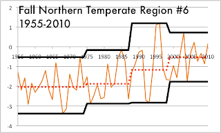
The Fall data has only one stutter step downward in the record high temperatures. The low and median readings rise a degree and a half in our time interval from the first era to the last, the record high goes up a degree.
The number of rises compared to the number of drops is 26-10. If we assume this should be 50%-50% - a fair assumption if our null hypothesis is "the general temperature is neither warming or cooling" - this lopsided win for the warmer weather is gives us a 99% confidence that this region is a warming region. On the other hand, the idea that it is warming faster over time doesn't work, since the increasing tall jumps are tied with the decreasing tall jumps at 12-12.
Tomorrow, we cross the International Date Line into the Western Hemisphere, region 7 dominated by the populated part of Alaska and the second region by the Canadian west and a small slice of the west coast of the United States.
Subscribe to:
Post Comments (Atom)


No comments:
Post a Comment